Dettifoss Waterfall
Dettifoss Waterfall
Dettifoss, located in Vatnajökull National Park, is Europe's most powerful waterfall. With a 44-meter drop and an average discharge exceeding 190 m³/s, it stands as one of Iceland's most breathtaking natural sites.
Dettifoss is Europe's most powerful waterfall. Situated in Vatnajökull National Park in northeastern Islande, it channels the waters of the Jökulsá á Fjöllum river into the Jökulsárgljúfur canyon. The average discharge exceeds 190 cubic meters per second, with the cascade plunging some 44 meters in height and spanning roughly 100 meters in width. The roar reaches your ears long before the water comes into view.
Quick Reference Guide
- Access: two road options — Route 862 (east bank, partially unpaved) and Route 864 (west bank, paved). The west bank offers the most direct approach from the Golden Circle.
- Admission: free.
- Suggested duration: 1 to 2 hours on-site, longer if combining with Selfoss (upstream) and Hafragilsfoss (downstream).
- Attire: waterproof jacket is essential—mist reaches observation platforms even in calm conditions.
- Accessibility: the west bank features a more accessible managed trail; the east bank is more rugged.
- Vehicle: a 4×4 is recommended for the east bank outside the summer season.
What to Expect
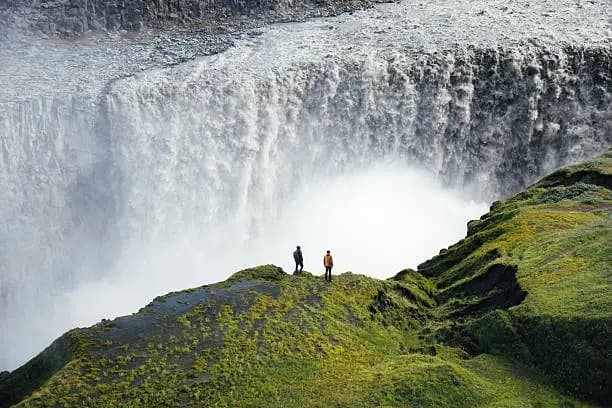
The waterfall itself dominates everything: a massive volume of grey, milky water laden with glacial sediment crashing into a basalt canyon. Hexagonal lava columns frame the cascade on both sides. On sunny days, rainbows form within the mist. Upstream, the Selfoss cascade—wider and less tall—offers a striking contrast.
History and Context
The Jökulsá á Fjöllum river originates beneath Vatnajökull, Europe's largest glacier. It travels roughly 200 kilometers before reaching Dettifoss. The Jökulsárgljúfur canyon was carved by cataclysmic glacial floods—known as jökulhlaup—during the last ice age. The site has been part of Vatnajökull National Park since 2008.
Highlights of Your Visit
The West Bank Observation Platform
The trail from the west bank car park (Route 864) reaches an observation platform in under 15 minutes. This offers the most direct face-on view: mist is intense, and you have an unobstructed sight line across the waterfall's full width.
The East Bank and Canyon Edge
From Route 862, the path hugs the basalt canyon's rim. The perspective is more vertiginous, with views down the gorge toward Hafragilsfoss. The black volcanic ground contrasts dramatically with white spray.
Selfoss Upstream
About 1 kilometer up the river from Dettifoss, Selfoss spreads across an even greater width but drops only about 10 meters. The trail between the two is walkable and level.
Hafragilsfoss Downstream
Descending the canyon from Dettifoss (roughly 2 kilometers), Hafragilsfoss presents a narrower cascade within a deeper gorge. Less visited, it rewards those who extend their hike.
Photography Tips
Raking light in early morning or late evening (in summer, the sun stays low even at midnight) casts a golden glow across the black basalt. Shield your lens from mist with a microfiber cloth. From the east bank, you photograph the cascade in slight upward angle with the canyon as backdrop. A polarizing filter reduces glare on the sediment-laden water.
Location and Access
Dettifoss lies roughly 30 kilometers east of the town of Húsavík and about 25 kilometers north of Mývatn. From Reykjavik, expect 5 to 6 hours by road via the Golden Circle (Route 1). Route 864 (west bank, paved) is accessible to standard vehicles in summer. Route 862 (east bank) may require a 4×4 depending on conditions. No regular public transport serves the site.
Nearby Attractions
- Mývatn Lake — volcanic lake with lunar-like landscapes, hot springs, craters, and lava fields to explore.
- Húsavík — Iceland's whale-watching capital, with regular sea excursions.
- Ásbyrgi — horseshoe-shaped canyon of mythological origins, about 30 kilometers north within the same national park.
- Krafla — active volcanic zone featuring the crater lake Víti and geothermal fumarole fields.
Frequently asked questions
June through September, both access roads are generally open. In summer, discharge is at its peak thanks to snowmelt. In winter, access is often impossible or extremely difficult, with roads potentially closed.
Route 864 (west bank) is paved and accessible to standard vehicles in summer. Route 862 (east bank) is partially unpaved, and a 4×4 is recommended, especially outside the summer season.
Yes. Selfoss (upstream) and Hafragilsfoss (downstream) are accessible on foot from Dettifoss. Allow half a day for all three. Mývatn and its attractions can round out your day.
Yes, without particular restrictions. Protect your gear from mist, which can be very heavy depending on wind direction.
A waterproof jacket is essential, even on clear days. Mist reaches the observation platforms. Waterproof hiking boots are strongly advised, as ground can be slippery.
The west bank (Route 864) delivers the most dramatic frontal view and easier access. The east bank (Route 862) offers a more vertiginous perspective of the canyon and sees fewer visitors. If time permits, both are worth experiencing.
Interested in this visit?
We can include it in your personalised itinerary.