Stuðlagil Canyon
Stuðlagil Canyon
Stuðlagil Canyon in eastern Iceland reveals hexagonal basalt columns and the turquoise-hued Jökulsá á Brú river. An exceptional geological site, accessible from June to September.
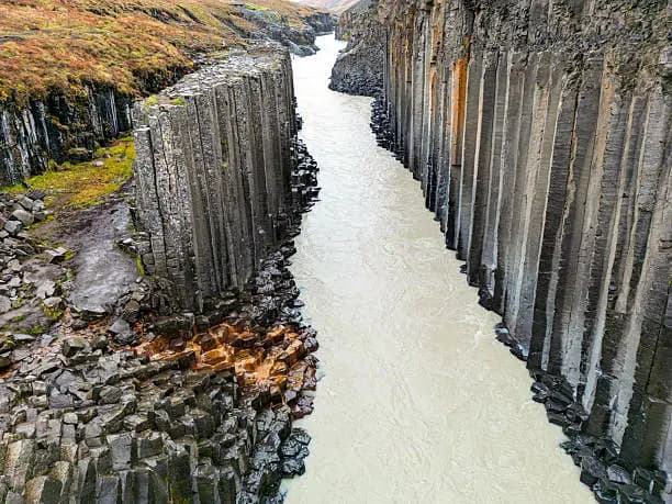
Stuðlagil Canyon carves through the Jökuldalur valley in eastern Iceland. It harbors the country's greatest concentration of hexagonal basalt columns, framed by the Jökulsá á Brú river with its turquoise waters. Long overlooked by travelers, it became accessible only after the construction of an upstream dam, which lowered the river level and revealed the columns. Today, it stands as one of Iceland's most spectacular geological sites.
Practical Information at a Glance
- Access: two accessible shores — east shore (Klaustursel parking, F910 track passable with 4×4) and west shore (Grund parking, accessible by standard car, but river crossing on foot required).
- Recommended duration: 2 to 4 hours depending on the shore chosen and walking pace.
- Entrance: free.
- Attire: waterproof shoes essential — river crossing is unavoidable on the west side.
- Accessibility for people with disabilities: very limited; terrain is rough and unmaintained.
- Recommended period: June to September (tracks open, river at low level).
What You'll See
The canyon walls are lined with basalt columns in hexagonal cross-section, formed by the slow cooling of lava flows. The Jökulsá á Brú river, fed by glaciers, takes on an intense blue-green hue between these dark walls. Secondary waterfalls cascade between the columns. Birdlife is present: red-breasted mergansers and Arctic terns frequent the banks.
History and Context
The canyon existed long before its media discovery, but the river largely submerged it. The commissioning of the Kárahnjúkar dam in the 2000s reduced the Jökulsá á Brú's flow, lowering the water level by several meters. The basalt columns, previously submerged or hidden from view, emerged. Photos posted on social media around 2017–2018 triggered a sudden influx of visitors.
Highlights of the Visit
The Basalt Columns
The geological formations reach several tens of meters in height. Their geometric regularity contrasts with the volcanic chaos typical of the Icelandic landscape. You can approach the base of the columns on the east shore.
The River Crossing (West Shore)
From Grund parking, the trail hugs the bank then requires a ford crossing. The water is cold and the current varies with the season. This approach offers the most photographed frontal view of the canyon.
The Panorama from the East Shore
Accessible by 4×4 via the F910 track, the east shore allows you to follow the canyon at height and descend to the river bed. The bird's-eye view of the columns and turquoise water is breathtaking.
Photography Tips
Light is optimal in mid-day summer, when the sun is high and illuminates the canyon floor directly. In the evening, the walls fall into shadow quickly. A polarizer reduces reflections on the water and intensifies the turquoise. From the west shore, a wide-angle lens captures columns and river in the same frame. Drones are technically possible but check Iceland's current drone regulations before flying.
Location and Access
Stuðlagil lies in the Jökuldalur valley, eastern Iceland, roughly 50 km north of Egilsstaðir. From Egilsstaðir, take Route 1 northbound then Route 923 into the valley. Two entry points exist: Grund parking (west shore, standard car) and Klaustursel parking (east shore, 4×4 required). No public transport serves the site. Access is seasonal: mountain tracks close in winter.
Nearby
- Egilsstaðir — eastern Iceland's main town, a logistical hub with services, accommodations and car rentals.
- Lagarfljót Lake — a large glacial lake famous for its milky waters and the legend of the serpent Lagarfljótsormurinn.
- Hallormsstaðarskógur Forest — Iceland's largest forest, on the shores of Lagarfljót, perfect for a nature break.
- Kárahnjúkar Dam — a monumental hydroelectric facility in the Highlands, directly linked to the canyon's revelation.
Frequently asked questions
From June to September, the tracks are open and the river level is low enough to ford across. Outside this period, access is difficult or impossible.
The west shore (Grund parking) is accessible by standard car. The east shore (Klaustursel parking) requires a 4×4 vehicle to use the F910 track.
It can be if the level is high after heavy rain or early in the season. The water is cold. Wear waterproof shoes and assess the current before crossing.
Yes. Egilsstaðir, Lagarfljót Lake and Hallormsstaðarskógur Forest are within an hour. A full day allows you to visit the canyon in the morning and these sites in the afternoon.
Access to the canyon is free. No entrance fee is charged on either shore.
Plan for 2 to 4 hours depending on the shore chosen and your pace. The east shore, with its descent to the river bed, takes longer than the west shore.
Interested in this visit?
We can include it in your personalised itinerary.