Vatnajökull
Vatnajökull
Vatnajökull covers 8% of Iceland and hides active volcanoes beneath its ice cap. Glacier hikes, winter ice caves, and the iceberg-filled Jökulsárlón lagoon make it an unmissable UNESCO site in southeastern Iceland.
Vatnajökull is Europe's largest glacier by volume, covering approximately 8% of Iceland's territory. Located in southeastern Iceland, it conceals active volcanoes, glacial lakes, and canyons carved by centuries of erosion beneath its ice cap. The national park surrounding it has been inscribed on the UNESCO World Heritage list since 2019.
Quick practical information
- Access: Route 1 (Ring Road) — main entrances are located on the Skaftafell side (west) and Höfn side (east).
- Park entry: Free for most areas; guided glacier excursions are paid (rates vary by operator).
- Recommended duration: A full day minimum; several days to explore different sectors.
- What to wear: Waterproof and warm clothing are essential, even in summer; crampons are provided by guides for glacier hikes.
- Safety rule: Never venture onto the glacier without a certified guide.
- Accessibility: Limited — fringe trails (e.g. Skaftafell) are partially accessible; the glacier itself is not.
What you'll see
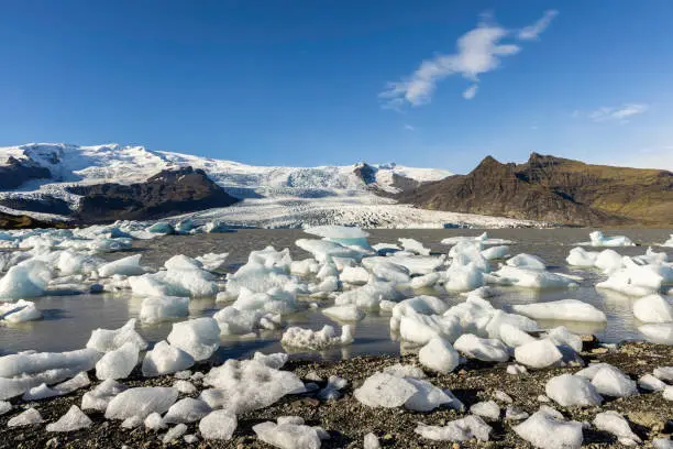
The ice cap extends across more than 8,000 km², with glacial tongues descending toward spectacular lagoons. The Jökulsárlón lake to the east is dotted with brilliant blue icebergs drifting toward the ocean. The Fjaðrárgljúfur canyon, the Svartifoss waterfall framed by black basalt columns, and the Lakagígar lava fields complete the panorama.
History and context
The name literally means "glacier of waters" in Icelandic. Beneath the ice rest several volcanoes, including Grímsvötn and Bárðarbunga, responsible for jökulhlaups — sudden floods triggered by subglacial eruptions. These phenomena have shaped the black sand plains of Skeiðarársandur. Vatnajökull National Park was established in 2008, then expanded and inscribed as a UNESCO site in 2019.
Highlights of your visit
Glacier hiking
Certified guides offer outings ranging from two to six hours on the glacial tongues of Falljökull or Svínafellsjökull. You'll observe crevasses, moulins, and compressed blue ice. The experience is accessible to beginners with reasonable fitness levels.
Jökulsárlón, the iceberg lagoon
At the eastern terminus of the glacier, this lagoon watches blocks of ice calve and drift slowly seaward. Amphibious boats allow you to navigate among the icebergs. The neighboring black sand beach, Diamond Beach, is scattered with translucent fragments cast up by the ocean.
Svartifoss and the Skaftafell sector
This waterfall plunges over a curtain of hexagonal basalt columns. The round-trip trail from the Skaftafell visitor center is well-marked and manageable without specialized equipment. It inspired the architecture of Reykjavik's Opera House.
Ice cave (winter)
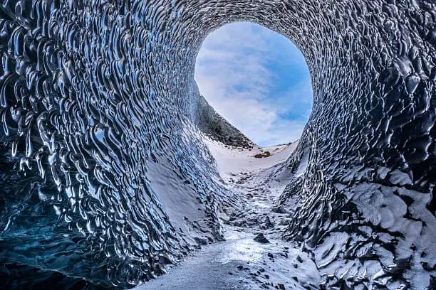
From November to March, guides lead groups into natural caves formed within the glacier. The ice takes on shades of deep blue. Entrances shift each year as the glacier evolves.
Photography tips
Raking morning and evening light reveals the blue nuances of the ice. At Jökulsárlón, sunset over the icebergs is particularly photogenic. In winter, the Northern Lights sometimes reflect in the lagoon. Avoid flash in ice caves: the ambient blue light is sufficient, and flash flattens textures.
Location and access
Vatnajökull spans southeastern and eastern Iceland. The Ring Road (Route 1) runs along its southern margins and provides access to major sites. From Reykjavik, allow approximately five hours of driving to reach Skaftafell. Höfn, the closest town to the east, serves as a base for exploring the Jökulsárlón sector. Long-distance buses operate on the Ring Road in summer, but a car remains the most convenient option. Domestic flights connect Höfn to Reykjavik.
In the vicinity
- Jökulsárlón — glacial lagoon with drifting icebergs, at the eastern edge of the glacier.
- Diamond Beach — black sand beach where translucent iceberg fragments wash ashore.
- Skaftafell — hiking area featuring the Svartifoss waterfall and direct views of the glacier.
- Fjaðrárgljúfur — winding canyon with moss and basalt walls, west of the park.
- Höfn — small fishing town renowned for its lobster, the eastern gateway to the glacier.
Frequently asked questions
Summer (June-August) offers nearly endless daylight and ideal conditions for glacier hikes. Winter (November-March) is the only season to access natural ice caves and observe the Northern Lights.
No. Crevasses and unstable zones make solo travel dangerous. A certified guide is mandatory for any glacier excursion.
Waterproof and warm layers are essential year-round. Operators typically provide crampons and harnesses for glacier outings.
Yes, if you start early from Höfn or Skaftafell. Plan a glacier hike in the morning and the lagoon in late afternoon to catch the golden light.
Yes, with no particular restrictions. A lightweight tripod is useful due to low light; flash is discouraged as it erases the blue nuances of the ice.
Partially. The Skaftafell visitor center and areas around Jökulsárlón have accessible zones. The glacier itself and hiking trails are not adapted for people with reduced mobility.
Interested in this visit?
We can include it in your personalised itinerary.